
Guides · · 4 min read
Point cloud to IFC: what you send, what you get back, and what to check
Turning a facade scan into an IFC model, from the buyer's side: what the scan has to be, what comes back, how long it takes, what it costs, and how to tell a good model from a bad one before you hand it to a client.
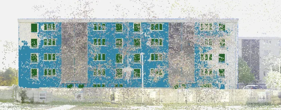
“Point cloud to IFC” sounds like a file conversion. It is not. A point cloud is a measurement; an IFC model is a set of claims about what the building is made of. Somebody, or something, has to make those claims, and the only question that matters to a buyer is how far you can trust them and how quickly you can check.
What the scan has to be
One file per project, in E57, LAS, LAZ or PLY, up to 5 GB. Two things matter about it, and neither is the scanner brand.
It must be registered, meaning every station expressed in one frame. Georeferencing is optional: a local frame works, and the model comes back in that same frame, so it lands where your other drawings are.
It should be dense on the facade. A few thousand points per square metre is comfortable; a few hundred is not, and the difference shows up as openings that are found on the dense facades and missed on the thin ones. Colour is used when the scan carries it, and it helps: it is what separates a door from a window and a grille from a patch of render.
What comes back
An IFC 4 model of the facade: walls cut by storey, windows, doors, vents, railings, terraces, copings, string courses and the plinths under them, as proper IFC entities with stable GUIDs, in metres, in your frame. Two variants ship: the proposal as generated, and the reviewed model built from your decisions.
With it come a PDF report, the viewer bundle and the evidence for each element. Nothing is a mesh, and nothing is a cloud pretending to be a model: an IfcWindow is an IfcWindow, and your authoring tool treats it as one.
What is not in it, in this version: interiors, roofs, terrain, mullions and screen rails. If your job is mostly one of those, this is not your tool yet, and we would rather say so here than after you have uploaded.
The part people underestimate: deciding what is right
Any automatic scan-to-BIM output contains three kinds of element. The ones that are correct, the ones that are wrong in a way you will notice, and the ones that are wrong in a way you will not. The third kind is the expensive one, and it is why a model that arrives as a finished deliverable with no evidence attached is worth less than one that arrives with its uncertainty marked.
So every element carries two things. A confidence, and a measured verdict: whether your cloud actually carried the evidence for that element’s dimensions, or whether a value was stated because the scan could not see it. A wall footed on a ground line the scanner never reached says so, on the element, in the file you open.
That is checkable without trusting anybody. Open the IFC in any viewer that shows property sets, sort by Measured, and you have your review list, on your own building, in your own software.
Why some elements cannot be measured
A terrestrial scan sees the face of a building. It does not see through it, and it does not see what a tree, a louvred screen or a parked van stood in front of. Those are not failures of software, they are what was in the street on the day, and no amount of processing recovers a surface that returned no points.
The honest consequence is that the share of elements shipping measured is a property of your building and your scan, not a promise. On a well scanned facade it is nearly all of them. On a thin street scan it is a minority, and it is precisely the parts standing behind something.
How long, and what it costs
The proposal takes minutes rather than days. Then your review takes as long as your review takes, which on a regular facade is about an hour and on a heavily screened one is longer, because the elements that could not be measured are the ones that need a person.
Charging is per square metre of facade actually modelled, and only when you download. Running a scan, looking at the proposal and reviewing it cost nothing, so the cost of finding out whether this works on your buildings is the cost of uploading one.
How to judge the output
Three questions, in this order, and they work on any supplier’s model, not only ours.
How much of the building did it find? Completeness first: an opening that was never proposed cannot be corrected by a reviewer who does not know it is missing. How much of what it drew is real? Invented elements are cheap to delete but they tell you how eager the system is. And which elements does it admit it could not measure? A supplier that returns no uncertainty at all is not more accurate, it is less forthcoming.
We publish our own answers to the first two on a named building, and we refuse to publish a single tolerance figure, for reasons set out on the Accuracy page. If you have a reference model of your own, send it with the scan and the run is scored against it, so the numbers you act on are yours rather than ours.
Questions
Can I convert a point cloud to IFC automatically?
For facades, yes: the openings and walls can be produced automatically as IFC entities. What no tool does reliably yet is decide for you which of those elements are right, which is why a review step exists and why you should distrust anyone who says it does not need one.
What point cloud formats can be converted to IFC?
The common terrestrial formats, E57, LAS, LAZ and PLY. The scan must be registered; a single station in its own frame works as well as a georeferenced multi-station scan.
How long does point cloud to IFC take?
Minutes rather than days for the proposal on a typical facade, then as long as your review takes. The slow part of scan-to-BIM has always been the modelling, and that is the part that goes away.